
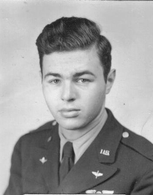
Fresh from Navigation School in Monroe, LA, I joined my permanent crew, commanded by Lt. Charlie Neundorf, in April 1944. We were assigned to B-24 Liberators, a four-engine heavy bomber remembered mostly as the "Flying Elephant" or the "Flying Boxcar." From Wyoming, we moved on to McCook, NE, and finally to Topeka, KS, our staging area. All this moving and practice took just over two months.
The gods decreed that we would take off from Topeka for Grenier Field, Manchester, NH, on 6 June 1944 (D-Day for some: Departure Day for us). We left in the early morning and I recall vividly my pilot's announcement on the intercom that the Allies had just started landing operations in Normandy - D-Day had begun. (He had picked this up from a commercial radio station in Cleveland).
There followed total silence in our plane, each of the 10 of us considering our near-term future.
After a few days at Grenier, we received orders to proceed to Goose Bay, Labrador. This destination had the ring of huskies, Malamutes and igloos, even though the date was early June. I was issued maps stamped "SECRET" for the flight, which made the war closer and more real.
The navigator's desk on a B-24 was located in the nose of the plane, the nose wheel and nose wheel doors being just a few feet to the rear. During takeoffs and landings, all personnel assigned to the nose area during flight had to move back to the rear of the pilot's cockpit on the catwalk.
After takeoff, I returned to my desk where I'd spread open my "secret" navigation charts. To my unpleasant surprise, my desk was totally bare. My "secret" maps had been sucked out of the nose wheel door during takeoff. I pictured them fluttering down into the waiting arms of a Nazi spy in downtown Manchester.
I reluctantly snapped on the intercom to advise Lt. Neundorf of my missing maps and was surprised by his calm reaction. We turned about, landed and I revisited the office that had issued me the maps. I was amazed by the disinterest of the personnel in simply giving me another set of "secret" maps for the flight!
This time I didn't lay my maps on the desk until after takeoff. I remember the feeling of the flight north, the totality of the forests and lakes below, passing over Anticosti Island in the St. Lawrence River, and thinking that the great adventure had begun!
We landed at Goose Bay and were assigned to barracks, doubledecker beds for officers. During the two nights we were there, I recall the strangeness of the sun setting at about 10:30 p.m. and rising again at 2:30 a.m. Sleeping in daylight was a new sensation, but not to be compared to green eggs and powdered milk!
I recall one dramatic incident in my brief adventure in the far north. My pilot, copilot and I walked off the base a short distance into the tall fair forests surrounding Goose Bay airfield. I have never forgotten that "sound of silence," but for the whispering wind in the tops of the high trees. It was a lack of sound I've always remembered.
Then came the morning for our departure for Prestwick, Scotland, a day I recall without difficulty. We attended our own private briefing, because air crews crossed the Atlantic by themselves - no formations or combinations of planes. I, as navigator, had a special briefing on the weather to be expected during the crossing.
Special maps for the North Atlantic were given to me, along with a small-scale map for plotting the route I hoped to follow and the actual track we would make on our flight. The size of the plotting map was important. It was about 24 inches wide, encompassing eastern Canada, Greenland, Great Britain and part of western Europe. This was perhaps 3,000 miles, westto east. This translates to about 125 miles to the inch -a lot of territory for a small distance on the map. As I studied this map, Ireland and Great Britain started to look small to me. Could I miss them completely and fly into Europe, all due to a small navigational error?
We took off from Goose Bay on 11 June 1944, and I remember seeing a few small icebergs close to shore as we headed out over the north Atlantic. Our initial headings were based on the forecast wind, to be adjusted by my navigational determinations, both visual wind readings via drift meter (from the ocean waves), and later during darkness by a celestial three-star fix.
There was one other factor we kept in mind for later in the flight. A German submarine had been reported to move around off the Irish coast, transmitting the same radio signal as an Irish station used by incoming Allied aircraft. Its purpose was to lure an aircraft to fly within range of its deck gun and to suffer an early end to its crossing. The sub had had some success.
Darkness came, stable air and a clear night sky were mine. I had no difficulty standing up with my octant in the overhead blister and taking good shots of three distant stars whose lines of position would intersect at wide angles. I did my plotting and drew my position lines. And what a beautiful fix it was! (I was a good celestial navigator. I flew a few "0-0" celestial missions coming down the main street of Texarkana and environs in my Selman days). It was a very tight intersection - no white space inside: just an exact position fix.
Now the next question-dare I believe it in fact, that we were 60 miles south of the projected path based on the Goose Bay forecast? That is what my fix stated. It was time for my decision and course correction. Doubting mortal that I was, I decided to give the pilot a halfcorrection, in case my fix was wrong. This meant that, if my fix was correct, we should cross the Irish coast over the Republic (neutral) of Ireland, 30 miles south of where we ideally should be.
Almost 50 years later, I realize I should have relied on it. But what 20-year-old navigator didn't yet have his full quotient of self-confidence? Based upon my half-correction, and having properly eluded the false signal from the German submarine, our plane made its landfall as predicted -30 miles below my desired position and over Eire, marked for identification to prevent aircraft over flights.
It took us only a few minutes flying north to cross over the border into Ulster (Northern Ireland, part of Great Britain), and were directed to land at an airfield to the west of Lough Neagh, a large body of water.
Ulster was very much like East Anglia in the proliferation of airfields. Lt. Neundorf called the tower and we were cleared to land on a specific runway. We landed, came to a stop at the end of the runway and requested taxi instruction. Then came a conversation with the tower who claimed we were not in their line of sight (the weather was clear and sunny). After a few radio messages as to our exact location, it became obvious what our situation was.
We were not invisible. We were simply sitting on the wrong airfield and talking to the correct control tower. So - after another embarrassed takeoff (if such is possible) we made a new landing on the correct airfield, and came to our final stop on the apron in front of the tower. A jeep appeared, and we were told to toss out all personal belongings and B-2 bags. Our plane was needed immediately for active assignment to a bomb group.
We jumped down to the concrete, bid adieu to the plane and were propelled along to our next assignment. My navigator's log states that we flew across "the ocean blue" on June 1 1-12, in a total time of 10 hours and 55 minutes.
The 392nd Bombardment Group (H) was the fourth B-24 Liberator unit to arrive in England from the United States in July 1943. By June 1944 there were 14 such units.
The 392nd was unique in that it was the first B-24 Group to have the Emerson nose-turrets, with two .50-caliber heavy machine guns, in the European Theater. Prior to this development and improvement (to counter the head-on attacks by enemy fighters) there was only one .50-caliber flexibly-mounted machine gun in the nose.
Col. Irvine Rendle, the group's first commanding officer, was a natural leader of men. I witnessed an example of his sterling qualities in the control tower at Wendling.
It was late in the afternoon of a typical gloomy winter's day with a very low cloud ceiling. Our aircraft had all returned from the day's mission when we heard the drone of a four-engine plane flying aimlessly overhead in the murk.
Barney Glettler, the flying control officer, turned to Col. Rendle and said, "There's a B-17 up there. The pilot's lost and he's beginning to panic." Col. Rendle took the microphone, briefly introduced himself to the unknown Fortress pilot, and in a calm, reassuring, but authoritative voice gave him the correct headings and literally talked him down through the clouds, guiding the bomber down to a safe landing on the main runway.